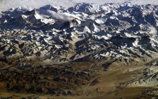
⬆ Everest, the North Face, Summer 2011 (KVH)
Continental tectonics is the field of earth sciences that deals with the evolution of the continental crust. An important aspect of this evolution – and the one we focus on extensively – is the development of mountain systems like the North Atlantic Caledonides, the Cordillera of western North America, and the Himalayan-Tibetan Orogen of South Asia.
Orogenic systems have complex behaviors that are shaped by the interplay of physical, chemical, and biological processes at scales ranging from a few microns to thousands of kilometers. As a consequence, the most effective way to study orogenesis is through a combination of field, laboratory, and theoretical research.
Our tectonics projects integrate across the fields of geochronology, thermochronology, structural geology, geomorphology, petrology, as well as thermal and kinematic modeling.
Active Projects
Complexities of the Deformation Field Across the Transition Between Tibet and the Himalaya
The physiographic transition from the steep and rugged topography of the southern flanks of the Himalayan ranges to the much more subdued topography of the Tibetan Plateau is among the most dramatic on Earth. This transition is remarkably abrupt, always occurring over a distance of 50-75 km, or less. It corresponds to a profound discontinuity in modern surface strain between the Tibetan Plateau and the Himalaya. To the north, the surface strain field of southern Tibet is one of essentially E-W extension expressed as N-S–striking normal fault systems and NW-SE–striking and NE-SW–striking transcurrent fault systems. To the south, the modern surface strain of the Himalaya is characterized by N-S contraction by deformation on active, N-S–striking, S-vergent thrust fault systems.
In conjunction with colleagues Kelin Whipple, Manoochehr Shirzaei, and Ramón Arrowsmith at ASU and Eric Kirby at Penn State, we have been studying the character of this transition and its relationship with active oblique-slip fault systems that cut across the dominant structural grain in the central Himalaya and become most prominent in the eastern Himalaya.
In conjunction with colleagues Kelin Whipple, Manoochehr Shirzaei, and Ramón Arrowsmith at ASU and Eric Kirby at Penn State, we have been studying the character of this transition and its relationship with active oblique-slip fault systems that cut across the dominant structural grain in the central Himalaya and become most prominent in the eastern Himalaya.
Publication
McDermott, J. A., K. X. Whipple, K. V. Hodges, and M. C. van Soest (2013), Evidence for Plio-Pleistocene north-south extension at the southern margin of the Tibetan Plateau, Nyalam region, Tectonics, 32, 317-333.
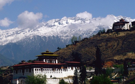
Late Tertiary Tectonics of the Himalaya Range Front in Bhutan
The topographic profile of western Bhutan is significantly different from that of other sectors of the Himalaya in a way that implies a distinctive tectonic evolution. The most strikingly distinctive feature of western Bhutan is an extensive low-relief "bench" at ~3000 m that interrupts the otherwise steep southern flank of the Himalayan ranges. Preliminary geomorphic analyses have led some researchers to suggest that this surface is a perched paleo-erosion surface that has been uplifted to its present position from a lower elevation. The postulated cause for the implicit accelerated erosion is a Late Cenozoic (post-Middle Miocene) change in deformation rate or kinematics or a change in climate.
Ph.D. candidate Byron Adams is leading our work – in collaboration with Kelin Whipple and Arjun Heimsath here at ASU – on the age, origin, and tectonic significance of important elements of the landscape of the Bhutanese range front through geologic mapping, landscape analysis, and argon and helium thermochronometry and geochronology. His work has recently documented the existence of a previously unrecognized, north-dipping, high-angle fault along the range front that has accommodated Quaternary preferential uplift of the foothills to the south relative to the higher Himalaya.
Ph.D. candidate Byron Adams is leading our work – in collaboration with Kelin Whipple and Arjun Heimsath here at ASU – on the age, origin, and tectonic significance of important elements of the landscape of the Bhutanese range front through geologic mapping, landscape analysis, and argon and helium thermochronometry and geochronology. His work has recently documented the existence of a previously unrecognized, north-dipping, high-angle fault along the range front that has accommodated Quaternary preferential uplift of the foothills to the south relative to the higher Himalaya.
Publication
Adams, B. A., K. V. Hodges, M. C. van Soest, and K. X. Whipple (2013), Evidence for Pliocene-Quaternary normal faulting in the hinterland of the Bhutan Himalaya, Lithosphere, 5, 438-449.
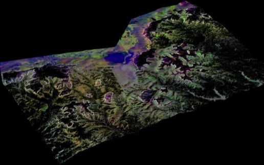
The South Tibetan Fault System in Bhutan and its Envrions
Among the more intriguing tectonic features of the Himalaya is the South Tibetan fault system, a family of Miocene north-dipping detachments and related transcurrent faults that typically trace near the crest of the high Himalayan ranges. In a few regions, putative klippen of the hanging wall of the master detachment apparently occur at lower elevations south of the high Himalaya. Some of the best examples are found in Bhutan, where recent postdoc Frances Cooper examined both the canonical exposures of the master detachment in the northwestern part of the country, as well as several of the klippen.
Combining structural geology, metamorphic petrology, U-Pb geochronology, and innovative uses of ASTER multispectral remote sensing data, Cooper has helped define the position of the master detachment. Collectively, these data indicate large (≥ 80 km), normal-sense displacements on this detachment in the Miocene. The oblique, NW-looking, decorrelation stretched ASTER image shown here demonstrates the distribution of klippen of the hanging wall of the master detachment (white line).
Combining structural geology, metamorphic petrology, U-Pb geochronology, and innovative uses of ASTER multispectral remote sensing data, Cooper has helped define the position of the master detachment. Collectively, these data indicate large (≥ 80 km), normal-sense displacements on this detachment in the Miocene. The oblique, NW-looking, decorrelation stretched ASTER image shown here demonstrates the distribution of klippen of the hanging wall of the master detachment (white line).
Publications
Cooper, F. J., Adams, B. A., Edwards, C. S., and Hodges, K. V., 2012, Large normal-sense displacement on the South Tibetan fault system in the eastern Himalaya: Geology, v. 40, p. 971-974.
Cooper, F. J., Hodges, K., V., and Adams, B. A., 2013, Metamorphic constraints on the character and displacement of the South Tibetan fault system, central Bhutanese Himalaya: Lithosphere, v. 5, p. 67-81.
Cooper, F. J., Hodges, K., V., and Adams, B. A., 2013, Metamorphic constraints on the character and displacement of the South Tibetan fault system, central Bhutanese Himalaya: Lithosphere, v. 5, p. 67-81.
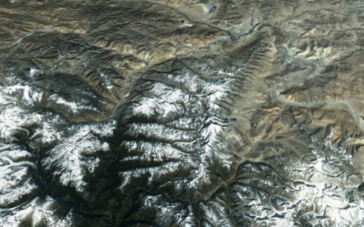
Extensional Processes and Bedrock Exhumation in the Upper Arun River Drainage, Southern Tibet
Much of the recent literature on the Himalayan-Tibetan orogenic system has focused on possible process linkages between the patterns of monsoon precipitation and deformational activity. We have focused some of our work on this topic on the region of southern Tibet where one of the great "Transhimalayan" rivers, the Arun, flows off the Tibetan Plateau and southward through the Himalaya to the Indo-Gangetic Plain. Near this transition is the Ama Drime Range (pictured here from space, looking northward) which is among the most dramatic transverse ranges in the Himalaya. Recent Ph.D. student Jeni McDermott is putting the final touches on her study of bedrock exhumation patterns within and around the Ama Drime Range. Her work shows that multiple generations of high- and low-angle extensional faults are responsible for the structural elevation of the core of the range, but that the pattern of Neogene-Quaternary bedrock exhumation outside the Ama Drime core is not dramatically different than that within the core. We are actively testing the hypothesis that this unexpected finding reflects focussed exhumation due to entrenchment of the Arun River.
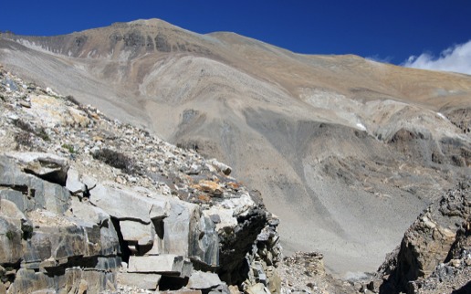
The Timeframe of Bedrock Exhumation North of the Himalayan Rainshadow
The notion of a direct correlation between monsoon precipitation and bedrock exhumation also suggests that the apparent ages obtained through low-temperature thermochronometry – using mineral-isotopic systems like apatite and zircon (U-Th)/He – should be much younger south of the range crest where precipitation has been high over much of the late Cenozoic than they are north of the range crest where precipitation has been lower. The young ages obtained outside the Ama Drime core are inconsistent with that prediction, but they may be influenced – as noted above – by focussed erosion along the Transhimalayan Arun drainage. This has prompted us to launch a new thermochronologic investigation of bedrock exhumation patterns north of the crest but not along a Transhimlayan river drainage. This study will begin with work in the Rongbuk valley, due north of Mount Everest (Chomolumgma) in the summer of 2013, and will be the focus of the Ph.D. dissertation research of Mary Schultz. As shown in the accompanying photograph, this high desert landscape offers superb exposures rich in minerals suitable for low-temperature thermochronometry.
Suture Zones of the Southern Tibetan Plateau
The Himalayan-Tibetan orogenic system has long been recognized as an amalgam of continental fragments separated by suture zones, but the correlation of these suture zones across major, post-suturing transcurrent faults – such as the Karakoram fault – is not always straightforward. A part of a broader, NSF Continental Dynamics project headquartered at the University of Arizona, Ph.D. student Nathaniel Borneman has been studying the comparative evolution of the Indus-Yarlung, Nidar, and Shyok suture zones in southern Tibet and northwest India through structural mapping, remote sensing image analysis, U-Pb geochronology, 40Ar/39Ar and (U-Th)/He thermochronology, and trace element geochemistry.
Structural Evolution and Bedrock Exhumation of the Tso Morari Dome, NW Indian Himalaya
The Tso Morari dome is a metamorphic core complex, structurally analogous to those found in the western North American Cordillera. Its core comprises coesite-bearing, eclogite-facies gneisses – evidence of continental subduction of the northern margin of Inda beneath Eurasia during the early stages of Himalayan orogenesis – as well as several structurally bound packages of blueschist- and amphibolite-facies rocks metamorphosed at shallower levels. On-going work, began by former M.S. student Ryan Clark and former postdoc Brian Monteleone, reveals that these packages are bound by rooted extensional detachments that are likely responsible for exhumation of the Tso Morari core. (Shown here - looking NW - is the structurally highest of these detachments, the Ribil fault, which places ophiolitic rocks of the Nidar Sequence on footwall high-pressure and ultrahigh-pressure rocks.)

Constraining the Age of India-Eurasia Collision
Continental sediments of the Indus Group of northwest India unconformably overlie the tectonic collage produced by India-Asia collision and thus provide a critical constraint on the age of the collisional event. Although deposition of the Indus molasse is widely regarded as having begun in Lutetian-Ypresian time, this perspective is not explicitly supported by paleontological or geochronological data. Other than the fact that most of the molasse must be younger than Ypresian nummulitic limestones, age-diagnostic fossils or volcanic horizons have not been identified throughout most of the section, and the stratigraphic position of the only well-documented fossil assemblage from the Indus Group (Upper Oligocene ostracods) is debatable. there are no firm constraints on the ages of any deposits in this important sequence.
Former Ph.D. student (and current postdoc) Alka Tripathy has led our work to improve our understanding of the age range, depositional history, and thermal evolution of this important succession. Our principal tools have been geologic mapping with the aid of multispectral satellite imagery, argon and helium thermochronometry, detrital zircon geochronology. Results supports the notion that India-Eurasia collision at this longitude culminated by Early Eocene, and that much of the complex backthrusting and backfolding found in the Indus Group is only a few million years old.
Former Ph.D. student (and current postdoc) Alka Tripathy has led our work to improve our understanding of the age range, depositional history, and thermal evolution of this important succession. Our principal tools have been geologic mapping with the aid of multispectral satellite imagery, argon and helium thermochronometry, detrital zircon geochronology. Results supports the notion that India-Eurasia collision at this longitude culminated by Early Eocene, and that much of the complex backthrusting and backfolding found in the Indus Group is only a few million years old.
Publications
Tripathy-Lang, A. K., K. Hodges, V., M. C. van Soest, and T. Ahmad (2013), Evidence of Pre-Oligocene emergence of the Indian passive margin and the timing of collision between India and Eurasia, Lithosphere, 5, 501-506.
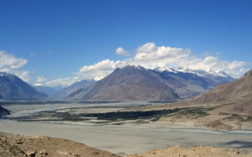
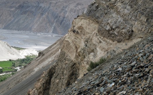
Pliocene-Recent Evolution of the Karakoram Fault System, Northwest India
The predominately right-lateral transcurrent Karakoram fault has played an important role in the structural development of the Himalayan-Tibetan orogenic system, but its most recent slip history has been controversial. Using a varied arsenal of geomorphic, structural, chronologic, and remote sensing techniques, Ph.D. student Wendy Bohon has been working to understand the slip history of this fault and related structures in the Ladakh region of northwest India, and the influence of these structures on the exhumation histories of the nearby Ladakh, Pangong, and Karakoram ranges. Shown here is a newly discovered thrust fault placing metamorphic rocks of the Pangong Range over poorly consolidated fluvial sediments. In the distance, looking northwest, is the steep northern flank of the Nubra Valley that marks the trace of the northern strand of the Karakoram fault in this area.
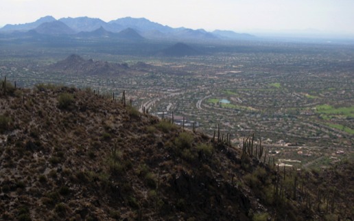
Footwall Exhumation History of the South Mountain Metamorphic Core Complex, Arizona
As a municipal park of Phoenix, South Mountain is one of the most accessible of the Cordilleran metamorphic core complexes. Michelle Aigner is completing a senior thesis project for which she is using zircon and apatite (U-Th)/He themochronology to constrain footwall exhumation during slip on the master detachment at South Mountain.